
Measured with a 200 km ruler, the coastline of Britain is about 2,400 km long. Measured with a 50 km ruler, it is about 3,400 km — a full 1,000 km longer. Neither measurement is a mistake. Keep shrinking the ruler and the answer keeps growing: kilometre sticks trace every bay, metre sticks trace every boulder, and there is no "true length" waiting at the end. This is the coastline paradox, spotted by Lewis Fry Richardson and made famous by Benoit Mandelbrot's 1967 Science paper, "How Long Is the Coast of Britain?". In this paper we will see why the paradox happens, and meet the strange but precise idea it gave birth to: a coastline whose dimension is not 1, but about 1.25.
Why shorter rulers find longer coasts
Imagine walking a pair of dividers along the coast, set to a fixed span — our "ruler" — and multiplying: length steps . A 200 km ruler strides straight across estuaries and skips whole peninsulas. Halve it and it must dip into bays it previously ignored — and every detour adds length. Halve it again and smaller wiggles appear, because a coastline has structure at every scale: gulfs contain coves, coves contain inlets, inlets contain rocks.
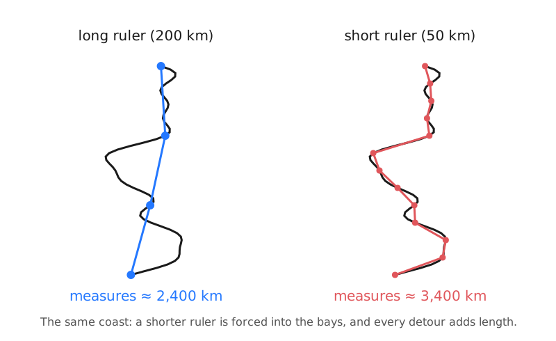
For a smooth curve like a circle this process settles down: shorter chords hug the curve better and the total converges to the circumference. A coastline never settles. That refusal to converge is the paradox.
The power law and its 1.25 dimension
Richardson measured coastlines and borders at many ruler sizes and noticed the growth was strikingly regular: plotted on logarithmic axes, length against ruler size fell on a straight line. In symbols,
where is a constant and is the exponent Mandelbrot later christened the fractal dimension. For an ordinary smooth curve , the exponent is zero, and stops depending on the ruler — as it should. For a coastline, and the length grows without bound as shrinks.
We can extract for Britain from the two measurements in our opening line. Taking the ratio kills the constant :
Taking logarithms and solving gives — the famous for the west coast of Britain. As a check, run the law forwards: starting from 2,400 km at and quartering the ruler multiplies the length by , predicting km. The data said 3,400. The power law fits.
A dimension of 1.25 sounds like nonsense — surely a curve is one-dimensional? The resolution is that measures not what the object is but how it fills space as you zoom in. Concretely: with , every halving of the ruler multiplies the measured length by — a reliable 19% bonus, at every scale, forever. A smooth curve pays no bonus (); a shape so wiggly it practically shades in an area would approach . The dimension is a wiggliness score, and real geography wears it honestly: Richardson's data give roughly for Britain's rugged, fjord-bitten west coast, about for Australia, and only about for the smooth coast of South Africa — barely wigglier than a plain curve.
This is not just seaside philosophy. Land borders are wiggly too, and Richardson noticed that official national figures disagree — substantially — about the length of the same border. Spain and Portugal share exactly one frontier, yet Spanish sources put it at about 987 km while Portuguese sources claimed about 1,214 km; Belgium and the Netherlands similarly disagreed at 380 km versus 449 km. Nobody was lying: the smaller country simply surveyed with a finer ruler, and by the power law above a finer ruler must report a longer border. Official factbooks still publish conflicting coastline figures today for exactly this reason.
So how long is it really?
So how long is Britain's coastline? The honest answer is that the question is incomplete: coastline length is not a property of the coast alone, but of the coast plus the ruler, growing without limit as the ruler shrinks. What is a genuine property of the coast is the exponent that governs the growth. Our model has honest limits — real coasts are only statistically self-similar, tides move the boundary hourly, and at sand-grain scales the power law gives up — but the lesson stands: sometimes a famous number simply does not exist. For a differently slippery British estimate, see our Loch Ness census.
References:
[1] Benoit Mandelbrot, "How Long Is the Coast of Britain? Statistical Self-Similarity and Fractional Dimension," Science 156 (1967), 636–638.
[2] Lewis Fry Richardson, "The Problem of Contiguity: An Appendix to Statistics of Deadly Quarrels," General Systems Yearbook 6 (1961), 139–187.
Note: The quoted lengths are Richardson-style divider measurements; real coastlines are only statistically self-similar over a range of scales, so D should be read as an empirical exponent, not an exact geometric constant.